Site Survey & Ground Investigation
Site Survey
Collis Civil Engineering can perform various types of detailed site surveys. The type of survey is selected based on how the data gathered will be used. Types of survey we offer are;
- Topographical survey

- As built Surveys
- 3D Scans
- Structural Surveys
- Site Layout Surveys
- Setting out
- Geotechnical
- Foundation surveys
Surveys can be carried out by Laser Total Station giving precise dimensional readings, dimensional (to ascertain the condition, position and lay out of existing structures, in particular mechanical), topographical (to ascertain the ‘lie of the land’ and aid in planning and setting out drawings) and geotechnical (to ascertain ground and soil characteristics to give the correct type of sub structure).
Desktop Study
An initial desktop survey is undertaken, involving the analysis of historical geological and geotechnical information. This allows us to make a preliminary assessment of the assumed ground conditions and to recommend a suitable ground investigation process.
Trial Pits
These are normally hand excavated to depths below ground level of up to 1.2 metres prior to undertaking a dynamic probe.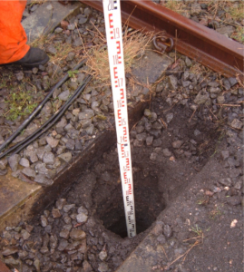 Findings of the trial pit are logged on the appropriate forms and checklist by a qualified engineer. Samples are collected and returned to the office for logging. Another benefit of the trial pit is that it acts as a double check for buried services or obstructions which may be inaccurate or missing on any buried service records.
At the base of the trial pit, if cohesive soils are encountered, five no, shear vane tests are undertaken to give a sheer strength value of the material.
Dynamic Probe
Provides a rapid and cost effective means of assessing ground conditions at specific locations. The probe involves driving a steel cone and rods into the ground using a sliding hammer, and recording the number of blows per 100mm of penetration. The rods are marked at 100mm intervals. The results from the Dynamic probe test can be correlated to give a Standard Penetration test N value ( SPT-N)
The cone Dia and angle will depend upon the chosen method. Collis offer hand held dynamic probe, with a fall weight of 10Kg and a heavy dynamic probe with a fall weight of 50kg. The preferred method is the heavy probe, however the hand held is good for sites with very poor access, as the kit can be manually carried to site.
It is usual to conduct a torque reading of the rods after each metre of penetration using a torque wrench in order to estimate the skin friction effects on the rods.
The depth of penetration achievable is dependent on the density of the material encountered and the type of probe undertaken. Readings are recorded on site by a qualified engineer.
Windowless sampling
Using the heavy dynamic probing rig sample tubes, containing plastic liners are driven into the ground to take undisturbed samples of the soil. We can achieve samples down to around 5.5m depending on ground conditions.
These sample tubes are sealed and labelled up on site, detailing the depth sampled, location and date of the investigation. These samples are then returned to the office for logging by our qualified engineers and any required laboratory testing.

The rig is set up over the proposed new location and steel soil sample tubes are driven in to the ground using a 50kg hammer rotating on a chain over a stroke of 500mm. The maximum depth is typically approximately 15 metres and their advantage over trial pits is that many can be sunk in a single shift to a greater depth and that they also show water levels easily.
On completion of the boring investigation the steel rods are recovered by means of the use of jacks. During the course of the works attention will be given to any evidence of water in order that the groundwater level beneath the site can be established.
Logging and reporting.
Following the completion of the ground investigation, all results are assessed by our geotechnical engineer, any samples logged and all findings are collated into a full Geotechnical Investigation Report. This report can also reference or include any available historical data for the area, ensuring that a detailed and accurate report can be provided for each site of work.